
Bexleyheath Clock Tower to Woolwich Arsenal station
Highlights:
- Erith Pier
- The Exchange
- Thames Barge Mural
1. Foresters Crescent bus stop
Russell Park is the first place to visit on this journey. It’s a big open space, great for a stroll or walking your dog and was at one time the site of the Bexley Isolation Hospital. The park is named after Mr Harry Pearn Russell, of Nine Gables Bexleyheath, a wealthy lawyer and well-known Bexleyheath citizen. He was a generous contributor to local hospitals – The Upton Hospital, and the Bexley Isolation Hospital. There are also the remains of air raid shelters within the park but they couldn’t be found on this occasion.


2. Erith Town Centre/Riverside bus stop
There is a considerable amount to be seen around here so be prepared to walk some distance. The bus stops opposite the White Hart pub where there is a lovely Thames Barge mural on the exterior wall. It’s the creation of artist Gary Drostle and it depicts a traditional Thames Spritsail Barge approaching the Erith shore at the end of the 19th century. The barge here is “The Chance” which had been skippered by a local character known as Robert “The Devil” Austen, who was a frequent drinker at the White Hart. Drostle used a technique known as trompe l’oeil and he painted over existing structures and pipes, which helped create a more theatrical appearance. There’s a sense of looking through a theatre curtain which is actually sails of other boats.
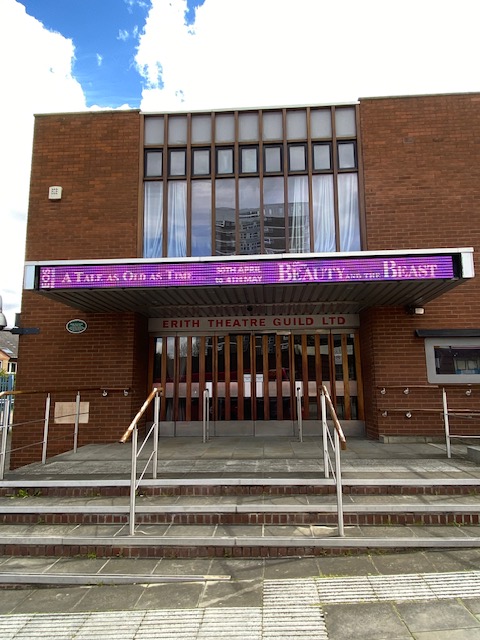
The pub is next door to the Playhouse Theatre. This started out life as a theatre in 1949 with the existing auditorium being part of the 1913 “Oxford cinema” which showed silent films at the outset. It remained a cinema until 1938 and during the war it was used as a furniture repository for bombed houses in the area.


From here, walk round to Erith Pier, the longest one in London. This wooden pier was opened on 22 August 1842, and expanded some 444ft (135m) into the river Thames. At the time, it was considered to be an exciting development. As well as the construction of the pier, the accompanying Pier Hotel was opened in 1844, offering holidaymakers a place to stop overnight, outside the city.
Two ships, The Diamond and The Star travelled between London and Gravesend calling at the pier daily, offering the gentlemen of Erith a luxurious means of getting into their offices in central London. According to old records, “members of the stock exchange would board one of the steamers and engage in a hearty breakfast with wine, and were the worse for it early in the day, and quite wrong when they returned at night.”
However, with the advent of the railway to Erith in 1849, the demise of the pier was swift. Commuters found it quicker to get to work by rail so demand for the boats decreased. On top of which raw sewage had been pumped into the Thames at high tide during 1865 with the assumption it would flow out sea-wards. It didn’t. As a result the pier and hotel (and a nearby Victorian garden) were all sold off by auction in 1865. More recently, the pier has had something of a transformation. The old wooden pier was replaced by one made from concrete and is sufficiently deep into the Thames and its tides, that it allows ships a safe berth.
Walk a short way and you’ll come across the Erith Causeway. This is a landing stage first built in 1909 for tenders for ship crews. It was renewed in 1951 and then in 1970. It extends into deep water at low tide and includes a 175m long 2.5m wide jetty currently used as a landing stage by Erith Rowing Club.


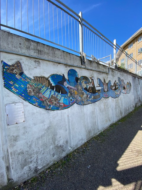
Continue walking along Riverside Walk and you’ll see a mosaic entitled Wildlife Superhighway. The inscription on the nearby plaque states “This mosaic was designed by local people to reflect the wildlife and beauty of the river Thames in Bexley. The tidal Thames provides a home for 118 species of fish and is the cleanest big city estuary in the world.” It was created by a local primary school and is one of three mosaics (though it doesn’t say where the other two are).
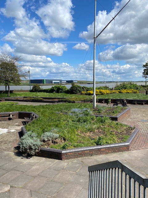
As you turn the corner from here, you will find yourself at Riverside Gardens, pretty landscaped gardens right on the river. The land for the gardens was partially gifted to the people of Erith by William Cory and Son, a major coal company in the area, which carried the fuel on barges up and down the River Thames.

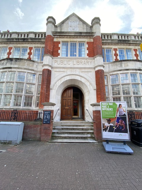
Still within the same area, walk round to The Exchange, a community hub housed in the former Erith Library. In 1906, local residents and communities clubbed together to build the area’s first public library, with the help of philanthropist Andrew Carnegie. They wanted to create a building that would inspire education, opportunity and community and that would belong to and be used by local residents.
The Erith-based architect William Egerton used the craft and talent of local carpenters, blacksmiths, plumbers and plasterers; used local bricks and timber merchants. The result was a stunning red brick building that would serve the local area for over 100 years.
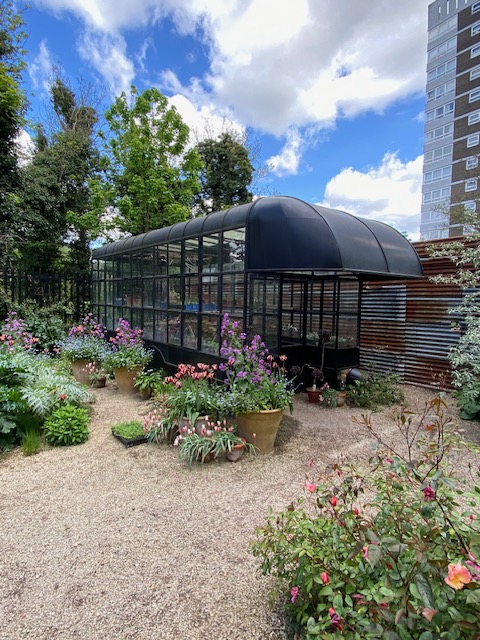
It is now once again a hub for community, celebrating local craft and working with local people. In particular, The Exchange is a place where people make things, such as furniture, ceramic tiles, plates and bowls, things like hand-made prints, cards and textiles. Using the rooms and space of the Old Library, it’s a hive of creativity and it’s possible to purchase some of the lovely products in the garden shop. The greenhouse in the garden is reminiscent of an old-style mobile library, which seems apt as it’s on the site of the Old Library.


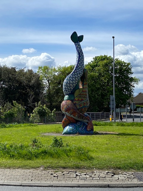
On the way back to the bus stop, there’s a cute mosaic sculpture in the middle of the roundabout. It’s The De Luci Fish sculpture and was created by artist Gary Drostle – he is the one who also made the Thames Barge Mural, shown earlier. The design was inspired by the old town coat of arms, which was adopted from the family arms of Richard de Luci. The aim of this piece was to create a celebration of the town that looked back at its long history and looked forward to its new focus as a riverside town.
While you’re here, you’ll pass Erith Town Hall, built in the Italian Renaissance style which was officially opened on 2 June 1932. It was used by the local council until it moved to civic offices in Bexleyheath. It’s a locally listed building and seems to be currently empty though it has been most recently offices for a large employer in the area.

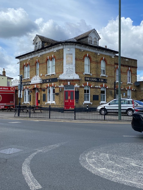
3. Eardley Arms bus stop
After spending a lot of time around the previous bus stop, it’s time for a change of scene. The bus stops opposite the Eardley Arms pub which dates from 1789 and is named after Sampson Gideon, first Lord Eardley (1745-1824) owner of Belvedere House. It was rebuilt in the 1860s.
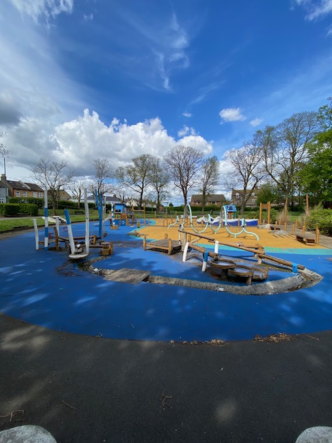
Then go to Belvedere Beach playground, one of two parks in the area. It’s very well planned out and is a beach-themed play area complete with pier, fishing boat, palm trees and pirate treasure chest. What’s really good about it is that children of all ages and abilities can play together and join in the fun. Belvedere takes its name from Belvedere House (see above) which was so-named because of its elevated position and its “beautiful view”.
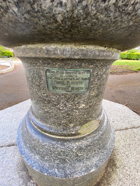
Interestingly, next to this splash park/beach, is a drinking fountain with the inscription “Miss Ellen Reardon’s bequest in memory of her father, mother and sister Daniel, Elizabeth and Margaret Reardon 1880”. Miss Ellen Reardon bequeathed in her will, the residue of her personal estate free of legacy duty to ten charities – one of which was The Metropolitan Drinking Fountain and Cattle Trough Association.
4. The View bus stop
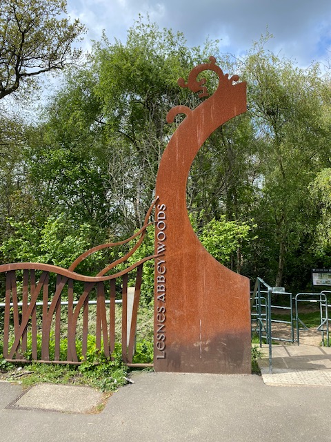
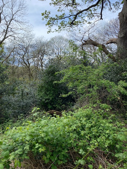
This bus stop takes you to Lesnes Abbey Woods, which are extensive and full of interesting places to see. However, the distance from the stop is possibly too far to get to the really great parts such as the Abbey Ruins and a lot of timber carvings. One of my rules is not to walk more than 10 minutes from any bus stop so I was prevented from venturing too far into the woods – another day, another bus route possibly. At any rate, it was all very lush and green and a beautiful walk.

5. Loneleigh Lane bus stop
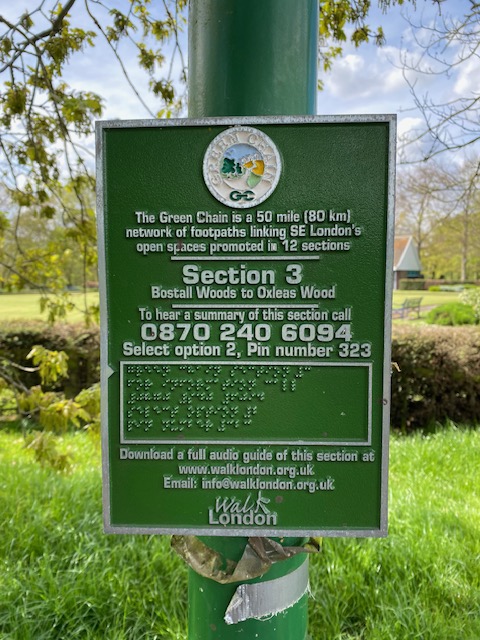
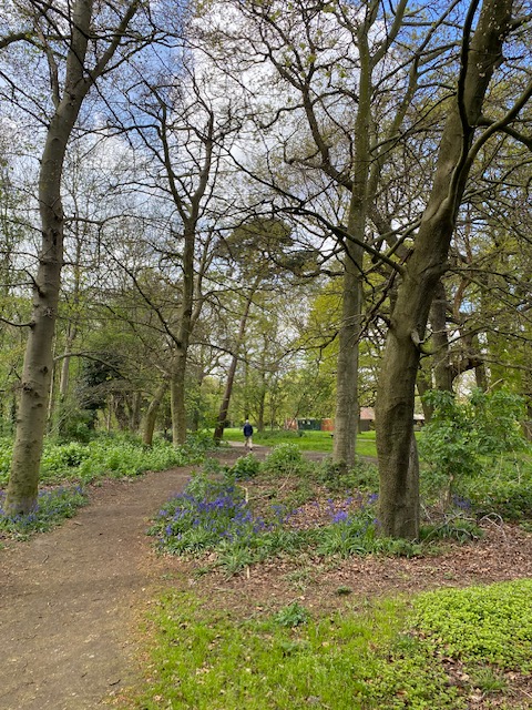
In case you hadn’t had enough of being outdoors, this stop takes you to Bostall Heath and Woods. This is part of a Green Chain walk that’s a network of 80km of footpaths that link South East London’s open spaces. The various walks are all sign-posted so you can head off in any direction you like and you’ll not get lost (in theory!). The bluebells are out at this time of the year (April) so do look out for them. The area was once the haunt of highwaymen. Although now bricked up, there’s a cave in the woods named after the most famous highwayman of all, Dick Turpin.


6. Plumstead High Street/the Plumstead Centre bus stop
The bus stops near Plumstead Library, yet another one built (in 1903) with the aid of philanthropist Andrew Carnegie, and part of which is grade II listed for its architectural interest. The library was originally laid out with the reading room in a well-lit north-east room, the newspapers and magazines in the large north-west room, and the adult lending library was held in the south-west, with a book store, offices, and a ‘music, art and study room’ partitioned off opposite. Today, the library still exists and the upper floor has been converted into a gym and leisure centre, though some of the early features remain.
Outside the library, one of the walls is adorned with a vibrant mural which was inspired by the artwork of students from a local school. You could be forgiven for thinking it’s graffiti thrown together on the wall but in fact there are a number of messages and reference to books – quite fitting for the outside of a library – and plums to reflect it’s in Plumstead.


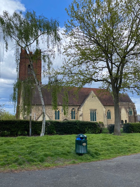
While you’re in the area, take a walk to see St Nicholas Church and Park. The church is dedicated to St Nicholas who was the patron saint of children, mariners, merchants, fishermen and prisoners – and he was the original Santa Claus. By the 12th Century, the church was surrounded by orchards and most of the congregation were fruit growers – the name Plumstead means “the place where the plums grow”. By 1800, the church had fallen into disrepair with trees growing in the aisles. The vicar who came in 1853 decided to replace it with another building on Plumstead Common but in the 1860s, work started once again on St Nicholas to house a congregation of nearly 300.
In 1907 a huge explosion in nearby Royal Arsenal damaged the church so badly that it had to be temporarily abandoned. And again in 1945 a German V2 rocket badly damaged the church and its churchyard. A few years later, when the church was restored to its former glory, the churchyard was converted into pretty gardens.


7. Beresford Square/Woolwich Arsenal station bus stop
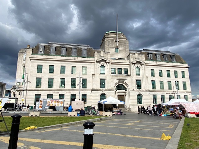
This is the end of the route and there is a lot to see in the vicinity – much of which has been reported in previous blogs. See bus routes 51, 54 and 96. Walk round to see the magnificent Equitable House. The building was home to Woolwich Equitable building society and later converted into a pub. It was originally built in 1935 and was the HQ until 1989. Since February 2024, the grade II listed property is for sale at £1.5m or rent at £75,000 per year.
Finally on your way back to the bus stop, you’ll pass Woolwich Arsenal station, which was rebuilt in 1992–93 to a modern design in steel and glass. It has a, clean, naturally-lit ellipsoid theme, in contrast to the earlier forms of design. The station is opposite Woolwich Market. This historic chartered market in Beresford Square has been there since the 1600s and sells a whole host of produce from shoes to clothing and fruit and veg.


If the number 98’s theme was around art and culture, the 99 is more about parks, gardens and open spaces. This means that if you intend to take this route, it’s a must to go on a fine day. The area near the start of the journey around Erith and the river, was particularly interesting and enjoyable and worth a visit on its own.
Toilets that are available to the public and free of charge:
- The Exchange
Belvedere Beach Recreation Ground
At Bostall Woods
Plumstead Library

One response to “Bus route 99”
Really great photos
LikeLike